Lidar Unveils Maya's Hidden Population Secrets
The Maya Civilization: A Revised Understanding of Population and Social Complexity
The Maya civilization, renowned for its remarkable achievements in architecture, astronomy, and social organization, has now revealed a much larger population than previously thought. A groundbreaking study published in the Journal of Archaeological Science: Reports revises earlier population estimates, showing a far more densely populated society during its peak. This revised estimate stems from an expanded analysis using lidar (light detection and ranging) technology, which maps the ancient Maya Lowlands with unprecedented accuracy.
Previous research had suggested a population of around 11 million, but the new data offers a more sophisticated view of the Maya’s vast network of urban and rural settlements. This shift in understanding not only alters the narrative about the Maya population size but also provides deeper insights into the complexity and interconnectivity of their society. As these new findings unfold, scholars are reexamining the structure of Maya civilization and its eventual decline, challenging many long-held assumptions.
The Role of Lidar Technology in Uncovering Maya Population Estimates
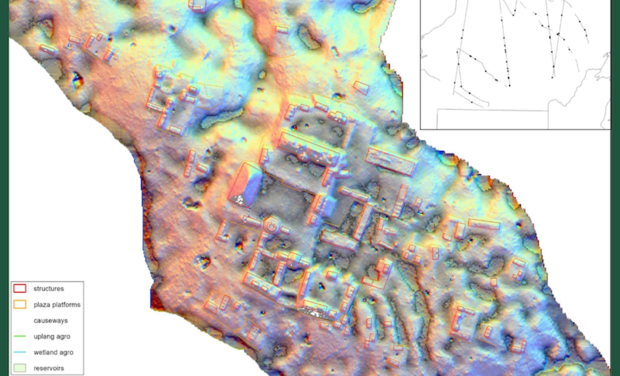
Lidar technology has revolutionized the study of ancient civilizations by providing a means to map previously hidden settlements beneath dense jungle canopies. By using lasers to generate 3D topographical maps, researchers can identify subtle traces of human-made structures and urban layouts that were otherwise invisible. This technology has been particularly beneficial in the case of the Maya civilization, whose cities and settlements were often hidden in the tropical rainforests of Central America.
The research team behind the latest study utilized lidar to scan an area of over 36,700 square miles (95,000 square kilometers) across Guatemala, Belize, and southern Mexico. The findings of these scans showed that Maya cities were not just isolated urban centers but part of a broader, highly interconnected network. According to Francisco Estrada-Belli, a research professor at Tulane University and lead author of the study, the team had initially expected only a modest increase in their population estimates based on the lidar data. However, they were “truly surprised” by the 45% increase in population, which suggests a far denser and more complex society than previously understood.
“We expected a modest increase in population estimates from our 2018 lidar analysis, but seeing a 45% jump was truly surprising,” Estrada-Belli said. “This new data confirms just how densely populated and socially organized the Maya Lowlands were at their peak.”
This technological leap has allowed researchers to more accurately gauge the extent of the Maya’s urbanization and understand the distribution of their population across both cities and rural areas. The lidar data does more than just confirm population numbers; it reveals how the Maya civilization was organized and how its society functioned on a much larger scale.
Unveiling the Complexity of Maya Social Organization
One of the most significant revelations of the new lidar data is the extent to which Maya society was structured. The new findings indicate that the Maya civilization was highly organized across both urban and rural areas, with a clear division of labor and centralized governance. The data shows a consistent pattern of settlement around central plazas, which were likely hubs for religious, political, and social activities. These plazas were often surrounded by residential areas and agricultural fields, indicating a well-planned and integrated society.
Estrada-Belli emphasizes that the lidar scans provide “hard evidence” of this advanced social structure. “We’re confident these lidar-based findings give us the clearest picture yet of ancient Maya settlement patterns,” he said. “We now have hard evidence that Maya society was highly structured across both cities and rural areas and far more advanced in resource and social organization than previously understood.”
The centralized layout of settlements around public spaces reveals a level of urban planning that was previously underestimated. The study suggests that the Maya were not only skilled in managing urban centers but also in overseeing rural agricultural production, which was crucial to sustaining such a large population.
This rethinking of Maya society has important implications for our understanding of how ancient civilizations structured their resources and organized their populations. It challenges earlier notions that rural Maya settlements were isolated and disconnected from urban centers, showing instead a highly integrated social fabric.
Reconsidering the Northern Maya Lowlands and Population Density
One of the most striking aspects of the study is the re-evaluation of the northern Maya Lowlands, which were once considered less urbanized than the southern regions. The lidar data has revealed that the northern regions were far more densely populated and urbanized than previously believed. The researchers found that the northern and southern parts of the Maya Lowlands had similar urban-to-rural density ratios, challenging earlier assessments that depicted the northern areas as predominantly rural.
“The northern Central Maya Lowlands were far from predominantly rural,” the researchers wrote. “The relative proportions of urban to rural density zones […] are remarkably similar between the southern and northern regions, challenging earlier assessments.”
This finding is crucial for understanding the distribution of Maya power and resources. It suggests that the northern regions were not merely peripheral or sparsely populated but played a central role in the social, economic, and political life of the Maya civilization. The extensive urbanization in the north, coupled with sophisticated agricultural systems managed by elites, indicates that the Maya were capable of sustaining large populations across a vast and varied landscape.


Comments
Post a Comment