Underwater city near Noah's Ark site challenges biblical narrative
Uncovering an Ancient Submerged City
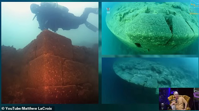
Beneath the surface of Turkey's Lake Van lies a mysterious underwater city that could hold secrets capable of reshaping our understanding of ancient history. This vast ruin is located 85 feet below the water near the town of Gevaş, just 150 miles from Mount Ararat, the mountain traditionally associated with Noah’s Ark.
Geological evidence suggests that these ruins were submerged between 12,000 and 14,500 years ago due to a massive eruption of Mount Nemrut. This event blocked the Mirat River and led to widespread flooding during the Younger Dryas, a period marked by extreme climate changes. While many scholars remain skeptical, some independent researchers believe this disaster may have wiped out an advanced civilization, one so ancient it could have inspired the earliest versions of the Great Flood story.
Advanced Stonework and Possible Global Connections
Matt LaCroix, an independent researcher, has been vocal about the significance of the site. He stated that no civilizations in the last 6,000 years had the technological capability to create the stonework seen at the site. LaCroix, who spoke about the discovery on the Matt Beall Limitless podcast, is part of a team preparing to explore the ruins in September using advanced imaging tools to map the area. He believes this exploration could help rewrite humanity’s timeline.
The underwater complex spans over half a mile, featuring a stone fortress flanked by circular temples with precisely carved masonry. A notable feature is a capstone engraved with a six-spoked 'Flower of Life' symbol, a motif also found at sacred sites in Peru and Bolivia. These similarities suggest possible connections between distant ancient cultures.
Discovery and Ongoing Debate
The ruins were first discovered in 1997 by Turkish underwater filmmaker Tossen Salin while studying Lake Van's micro-invertebrates. Despite their existence being confirmed by archaeologists, many attribute them to the Urartian period around 3,000 years ago or even the medieval era. However, they have admitted that the site remains largely unstudied and undated.
LaCroix, in a July episode of the podcast, emphasized that geological data tells a different story. He explained how soil sampling and analysis of Mount Nemrut show clear evidence of a massive eruption around 12,000 years ago. According to some estimates, this caused Lake Van's water level to rise dramatically by over 100 feet.
Challenges and Potential Discoveries
The challenge of dating the ruins lies in the fact that stone cannot be carbon-dated. Researchers hope to find organic material such as sediment layers or artifacts to confirm the age of the structures. However, collecting such evidence underwater poses significant challenges.
The site’s sophisticated stonework, with tightly interlocking blocks and angular joints, rivals the engineering seen in megalithic sites like Sacsayhuamán in Peru. LaCroix described the damage to the temple, noting that all the stones on the top have broken off except those at the edges. He highlighted the beauty of the precise angles and triangular joints, suggesting that the site would have been perfectly carved.
Shared Architectural Features and Cultural Links
LaCroix believes the shared architectural features, symbolic motifs, and astronomical alignments across sites in Turkey, South America, and Asia point to the existence of a long-lost global civilization. Scholars have long acknowledged that the biblical flood story likely evolved from earlier Mesopotamian texts.
Ancient cuneiform tablets from Sumerian, Akkadian, and Babylonian cultures, such as the Epic of Gilgamesh, the Atrahasis, and the Eridu Genesis, describe a massive flood sent to destroy early civilization and a chosen man who builds a vessel to save life on Earth. In these tales, the survivor is called Ziusudra or Utnapishtim, names predating Noah by thousands of years.
Physical Evidence and Historical Context
Excavation logs from Shuruppak, Iraq, believed to be the home of this early flood survivor, show a distinct flood layer above ancient Sumerian ruins. These records, uncovered at the Penn Museum, provide physical evidence of a catastrophic event similar to those described in the ancient texts. Even the Babylonian Map of the World, the oldest known map, marks the Ararat region near Lake Van as a place of ancient significance, possibly linked to tales of a lone survivor who emerged after a global deluge.
LaCroix argues that the biblical version is not being dismissed but rather reframed in its historical and cultural context. He envisions a thriving civilization along Lake Van, building temples and structures on stable, elevated ground they believed would last forever. The lake’s water level remained stable for millennia until the eruption of Mount Nemrut changed everything.
The Rising Water Level
LaCroix emphasized that the lake would have had to be significantly lower for the ruins to be at 85 feet deep. "It would have had to have been more like 100 feet lower or more," he said. "What could account for a lake rising over 100 feet?" This question underscores the mystery surrounding the site and the potential for groundbreaking discoveries.


Comments
Post a Comment