Hurricane Kiko Threatens Hawaii with Floods and Mudslides
Hurricane Kiko Threatens Hawaii with Unprecedented Power
As the Pacific hurricane season continues, Hurricane Kiko is emerging as a major threat to the Hawaiian Islands. Forecasters are closely monitoring the storm, which has intensified into a Category 4 hurricane and is now on a path that could bring it directly over the Big Island, Maui, Molokai, and Oahu. The potential for severe weather, including torrential downpours, flash flooding, and deadly mudslides, has raised concerns among residents and officials.
Kiko’s trajectory is of particular concern due to its projected landfall by Tuesday afternoon local time. This timeline places the storm in direct contact with some of the most populated and tourist-heavy areas of the state. The National Hurricane Center (NHC) is still assessing the exact intensity of the storm when it reaches Hawaii, but meteorologists warn that even if Kiko weakens, its impact could be devastating.
The storm has already strengthened to sustained wind speeds of 145 mph, and there is a possibility it may reach Category 5 status with winds exceeding 157 mph. According to Alex DaSilva, AccuWeather’s lead hurricane expert, Kiko is entering an area of the Pacific that will continue to fuel its growth. However, experts also note that the storm may begin to lose strength as it approaches cooler waters near Hawaii and encounters increased wind shear.
Wind shear can disrupt a hurricane’s structure, potentially weakening the storm before it makes landfall. Despite this, Kiko remains a significant threat. Its potential to cause widespread damage echoes the devastation brought by Hurricane Iniki in 1992, which struck as a Category 4 hurricane and resulted in six deaths, over 1,400 destroyed homes, and $3 billion in damages.
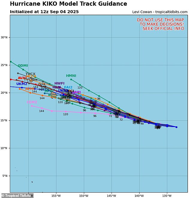
Hawaii’s geography, with its large mountains and the Big Island, often acts as a natural barrier against hurricanes. However, even a near-miss can lead to serious consequences, as these storms can extend hundreds of miles across the ocean. Currently, only two possible tracks suggest Kiko will move away from the islands, while several others predict a direct hit on the Big Island or Maui.
Meteorologists use spaghetti models to track the potential paths of hurricanes, with each line representing a different computer model's prediction. When these lines converge, it indicates a higher level of confidence in the storm’s trajectory. For Kiko, the latest models have shown a more consistent path, increasing the likelihood of a direct impact on the islands.
At this stage, no official hurricane warnings have been issued in Hawaii, as the storm is still approximately 1,300 miles east of the Big Island. However, minor coastal flooding is expected Sunday along shorelines and low-lying areas. Meteorologist Guy Hagi has indicated that advisories regarding dangerous ocean swells could be issued as early as Monday.
Kiko is the 11th named system in the eastern Pacific this year, and the hurricane season is far from over. It runs from May 15 to November 30, making it two weeks longer than the Atlantic season. Earlier predictions from the National Oceanic and Atmospheric Administration (NOAA) suggested a "below-normal" season, with 12 to 18 named storms, five to 10 hurricanes, and up to five major hurricanes.
Another Pacific hurricane, Lorena, briefly formed earlier this week before breaking down into a tropical storm heading toward the U.S. West Coast. As Kiko continues its journey, the focus remains on how it will evolve and whether it will maintain its strength as it approaches Hawaii.
With the potential for catastrophic damage, residents and officials are preparing for the worst. The question remains: Will Kiko follow in the footsteps of Hurricane Iniki, or will it weaken before reaching the islands? Only time will tell, but one thing is certain—Hawaii is bracing for a major weather event.


Comments
Post a Comment