Map uncovers 1,300 cancer-linked toxic sites across the US
Methane Leaks and the Invisible Threat to Public Health
Thousands of Americans are living in the direct path of invisible toxic gas clouds from 'super-emitter' methane leaks across the country. These leaks, often undetected due to the odorless and colorless nature of methane, pose serious health risks to communities located near oil and gas infrastructure.
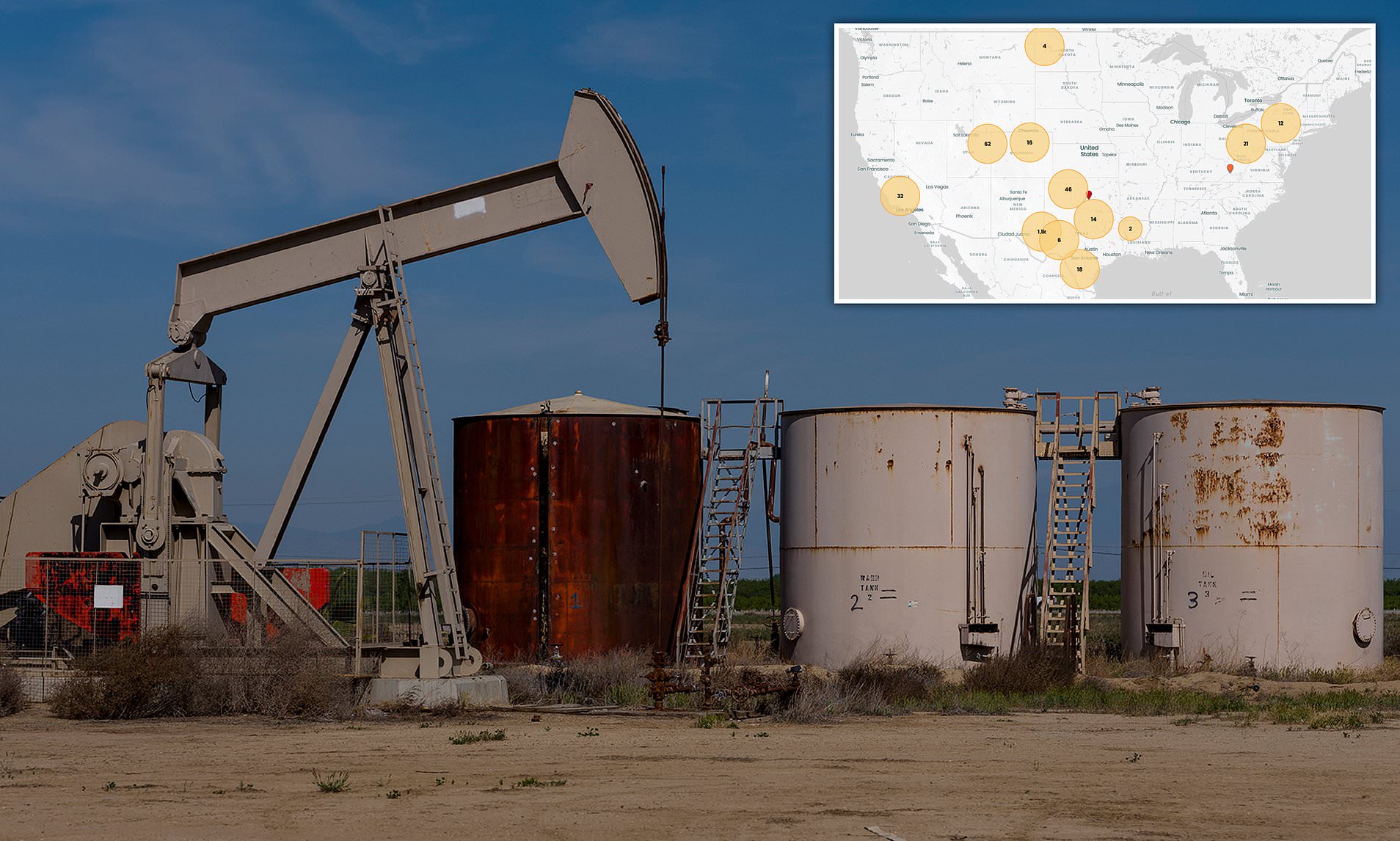
A non-profit science institute based in California, PSE Healthy Energy, has developed an interactive map that models the spread of dangerous air pollutants released during major methane leaks. This groundbreaking tool uses data from over 1,300 leaks nationwide, highlighting the potential dangers faced by millions of people.
Methane, a potent greenhouse gas, is the primary component of natural gas. When it escapes from oil and gas infrastructure due to equipment failure or ruptures, it carries with it a wide array of hazardous co-pollutants, including known human carcinogens such as benzene, toluene, ethylbenzene, and xylene. These substances can have severe health impacts, especially when inhaled over long periods.
The research team found that 127,000 Americans and over 100 sensitive facilities, like schools and hospitals, are located within two miles of major oil and gas leaks. This exposure puts vulnerable populations at risk, with the danger increasing as concentrations rise and exposure times extend. Long-term exposure to these toxic chemicals has been linked to leukemia, central nervous system damage, organ damage, and mental illness.
In addition to immediate health risks, the initial plume from a leak can last from minutes to several hours. Benzene and other volatile organic compounds (VOCs) can seep into the soil or contaminate groundwater, later off-gassing back into the air over years, creating persistent low-level indoor and outdoor air exposure.
New Mexico had the highest number of leak sites, with more than 770 recorded. In nearly every case, levels of cancer-causing benzene exceeded state safety benchmarks, putting nearby residents at risk without their knowledge.
The Environmental Protection Agency (EPA) sets national methane standards, which include monitoring, leak repair, and zero-emission equipment. States must enforce these rules and may implement stricter ones. A key element is the 'super emitter' program, which mandates immediate response to leaks exceeding 100 kg of methane per hour.
Many super-emitter sites identified by PSE Healthy Energy have methane concentrations far above this threshold. For example, Bienville Parish, Louisiana, recorded a concentration of 1,320 kg per hour, while Reagan County, Texas, exceeded 3,500 kg per hour.
Access to information about toxic chemicals released during fossil fuel extraction and transportation is often limited. To address this gap, PSE Healthy Energy scientists undertook a sweeping effort to create their own database of chemicals found in oil and gas emissions. They collected gas samples from wells across 11 top gas-producing states and analyzed thousands of air permit applications submitted by energy companies.
The result was the largest and most comprehensive database of its kind in the US, covering data from 2016 to 2025. The study revealed that methane emissions encompass a toxic mix of chemicals beyond just methane itself. Nearly every sample contained BTEX compounds, which are highly toxic and linked to various health issues.
Long-term exposure to toluene can cause permanent brain damage, while ethylbenzene has been linked to hearing loss and blood cancer. Chronic exposure to xylene can lead to headaches, dizziness, and heart disease. Almost all sites released amounts of benzene that health experts say can cause severe health effects, including leukemia and fertility problems in men.
In Colorado, where 21 emission sites exist, researchers found that children living near oil and gas wells had a significantly higher risk of developing leukemia. Specifically, children aged two to nine living within 3.1 miles of high-activity gas-emitting sites were twice as likely to be diagnosed with leukemia compared to those not living near such operations.
Because methane has no color or smell, detecting leaks is nearly impossible without specialized tools. Sofia Bisogno, an air quality scientist with PSE, emphasized the importance of awareness. She noted that many events are not covered by local media, leaving communities unaware of the potential dangers.
The non-profit’s tool was developed in response to concerns that deregulatory actions under the Trump administration would increase methane pollution. In February 2025, Congress scrapped a rule that would have charged big oil and gas companies for excessive methane emissions. This plan, called the Waste Emissions Charge, would have started at $900 per ton in 2024 and risen to $1,500 per ton by 2026.
Methane, with 80 times the heat-trapping potency of carbon dioxide, is a major driver of climate change. Previous scientific research suggests that emissions from the oil and gas sector are nearly triple the levels reported by the EPA.
Kelsey Bilsback, principal investigator on the map, stated that the emissions events the team located represent only a small fraction of methane emissions events happening across the country at any given time. The map provides a vast undercount of the number of people at risk.
No death certificate in the US has ever listed air pollution as the cause of death, but researchers have estimated that harmful emissions are responsible for roughly 200,000 premature deaths annually. As awareness grows, the need for stronger regulations and public education becomes increasingly urgent.


Comments
Post a Comment