Tinau River Turns Black After Coal Mine Landslide
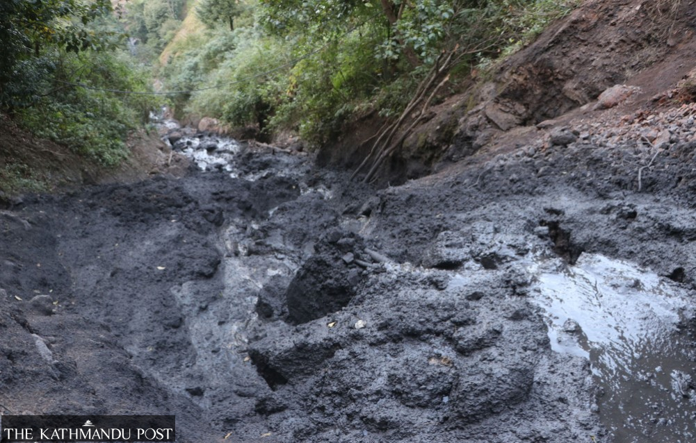
The Muddy Waters of Tinau River: A Growing Environmental Concern
The Tinau River, which originates in Palpa, has recently experienced a dramatic change in its water color. What was once clear and flowing smoothly has now turned muddy and black, sparking widespread concern among locals and authorities alike. Social media has played a significant role in amplifying the issue, with numerous photos and videos capturing the alarming transformation.
A police team from the Purvakhola Area Police Office visited the site of the landslide that is believed to be responsible for the discolored water. Senior Police Head Constable Netra Bahadur Bhat Chhetri explained that although the water source at the site is small, it has carried black silt downstream, contributing to the river's current condition.
Raj Kumar Panthi, chair of Ward 1 in Chidipani under the Mathagadhi Rural Municipality, confirmed that the river had been flowing in a murky and dark state for several days. He noted that the initial appearance of the water seemed normal due to embankment work upstream. However, as the flow continued, the situation became more apparent, leading to increased awareness among the local community.
During the rainy season, it was common to see silt in the river, but recent reports indicate that the silt has taken on a darker, coal-laden hue. Khem Bahadur Baral Magar, a local resident, explained that the source of the problem is small but exacerbated by steep slopes and coal runoff. The presence of coal mines at the landslide site further compounds the issue, as the water carrying black silt flows into the Tinau River towards Butwal via Madi, making the river turbid.
Environmental experts have raised alarms about the safety of the water, warning that it is unsuitable for irrigation, domestic use, or livestock. Several coal mining sites operate in the area, and previous reports have indicated that water passing through these mines is unsafe for drinking, irrigation, or livestock.
Yubaraj Kandel, an environmentalist, highlighted the dangers associated with the water's increased carbon dioxide content, which can negatively impact aquatic life and plant growth. He explained that the silt contains pyrite along with coal, increasing the water's acidity and making it unsafe for consumption or irrigation. Acidic water can leach harmful substances like arsenic, lead, and copper from rocks into the river, reducing dissolved oxygen and harming aquatic life. Additionally, the silt settles in the riverbed, destroying natural habitats.
Locals are aware of the environmental impact of coal mining. Bir Bahadur Gaha, a local resident, mentioned that when the mines were active, environmental experts warned them about the negative effects. "We know the black water is not suitable for irrigation or livestock," he said.
According to local accounts, a small landslide two years ago has now expanded dramatically. Shrubs and bamboo groves have been swept away over nearly 200 meters, and in the past month, an additional 100 meters of landslide occurred. Shivlal Gaha, another local, described the challenges faced by residents in reaching their fields and transporting harvested rice due to the landslide. A journey that once took 30 minutes now takes 90 minutes. "Until Dashain, the dirt path was passable, but now an additional 30 meters has been washed away," he said.
While there is no immediate danger, 12 houses are at risk due to the landslide. The police have urged these households to stay alert. In recent days, the administration, local authorities, and residents have expressed growing concern. Senior Police Head Constable Chhetri advised people not to use the water for irrigation or drinking.
Coal mining was active in Devinagar, ward 4 of Purbakhola Rural Municipality, until six years ago, but operations ceased due to irregular and careless extraction. Coal mines were also present at the current landslide site. Mehar Singh Thapa, the ward chair, emphasized the need for caution among residents downstream, as black silt continues to flow from the river's source. "Our capacity to act is limited," he said, adding that he plans to request a study from the Department of Soil and Watershed Management.


Comments
Post a Comment